Sentinel-2 for mapping Techno-soils in South-India:
Red soils and black soils are both used as cropland in South-India. Black soils have a more important content of clay that increase the Soil Water Available Capacity. A singular agricultural practices has been observed in-situ, in the scientific observatory Berambadi catchment, in Karnataka, South-India. Farmers are moving black soils, rich in clay, from the dried bottom of small surface reservoirs to their crop parcels. A study conducted by a colleague from the LISAH laboratory (Montpelier) have mapped this practice using Sentinel-2 images.

Tropospheric N2O monitoring from space:
SOFRID (Software for a Fast Retrieval of IASI Data) developed in Laboratoire d'Aérologie (Toulouse) was modified to estimate the spatio-temporal variability of Nitrogen protoxyde from IASI satellite thermal data. N2O is the third greenhouse gas responsible of global warming, because it accumulates in the troposphere from natural and anthropogenic sources, especially nitrate fertilisation. The aim of this project is to identify, from this global dataset (since 2008), hot spot and hot moment of N2O emissions from croplands.
Retrieval of Metop-A/IASI N2O profiles and validation with NDACC FTIR data – Atmosphere Brice Barret, Yvan Gouzenes, Eric Le Flochmoen and Sylvain Ferrant https://doi.org/10.3390/atmos12020219
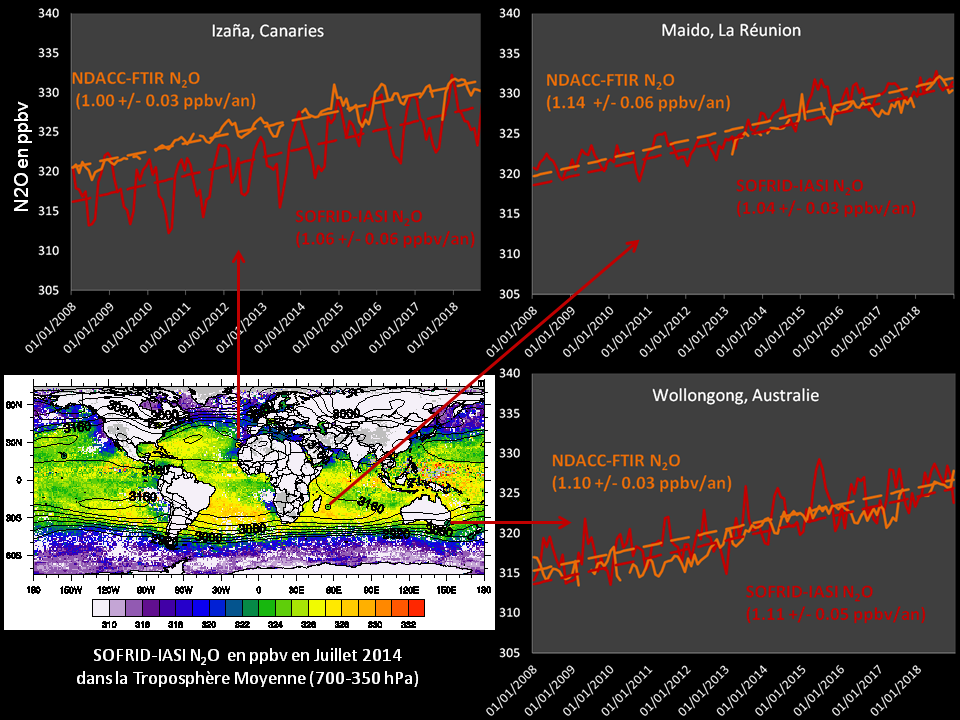
Global retrieval from IASI-SOFRID N2O tropospheric concentration validated with 12 ground stations, part from the NDACC observatory.
Space Climate Observatory (SCO) StockWater project:
Sentinel and global DEM to monitor the surface water volume in large and small reservoirs in Europe, India, South-East Asia and Sahel
In collaboration with CNES teams, this project aims at developing and validating methods to estimate water volumes in surface reservoirs by extrapolating bathymetry from Global DEM at 30 meters resolution and surface water area extent dynamics from Sentinel data.
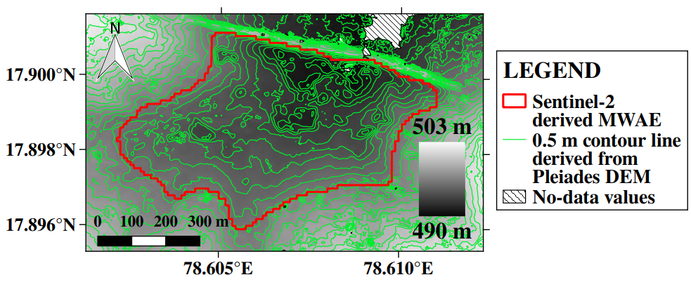
Water4Agri3D:
Sentinel surface water dynamics and Pleiades derived very high resolution DEM to monitor the surface water volume
Very high resolution stereoscopy DEM derived from Pleiades stereoscopic acquisitions during dry period were used to map a true bathymetry of hundreds of emptied small reservoirs composing the Water Harvesting system in Telangana, South-India.
One typical small surface reservoirs resulting from an impoudment with an earthen dyke, composing the water harvesting system maintained by indian farmers to catch monsoon runoff. Intermittent, they provide water during dry season.
ForEarth project:
Sentinel-1 to monitor surface water area extent in South-India:
Radar data from Sentinel-1 have a clear advantage on optical Sentnel-2 data: image acquisitions can be made during the 4 months of monsoon, under a quasi permanent cloud cover, to catch the maximal water area extent stored in the hundred of thousands of small reservoirs and hundreds of large dams found in Telangana state, South-India. A machine learning algorithm is employed with ancillary data (Digital Elevation Model, Global Surface Water database derived from Landsat optical images) to get the surface water area extent at the regional scale. The ESA science4society project ForEarth aimed at providing the dynamical surface water maps and inundation statistics at the Telangana level, using a smartphone app, ForEarth. More info here.
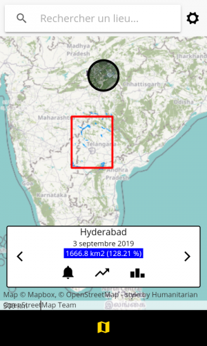
Visual of ForEarth application on Telangana state.
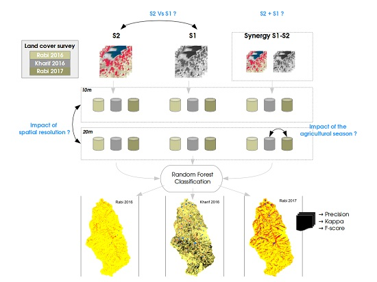
Sent4IrrigationWater:
Sentinel-1&2 for Irrigation water needs estimates in South-India:
Indian agriculture relies on monsoon rainfall and irrigation from surface and groundwater. The inter-annual variability of monsoon rainfalls is high, which forces South Indian farmers to adapt their irrigated areas to local water availability. In this study, we have developed and tested a methodology for monitoring these spatio-temporal variations using Sentinel-1 and -2 observations over the Kudaliar catchment, Telangana State (~1000 km2).
S. Ferrant, Adrien Selles, M Le Page, A AlBitar, S Mermoz, Simon Gascoin, A Bouvet, S Ahmed, Y Kerr (2019), Sentinel-1&2 for near real time cropping pattern monitoring in drought prone areas. Application to irrigation water needs in Telangana, South-India. In International Archives of the Photogrammetry, Remote Sensing and Spatial Information Sciences-ISPRS Archives (Vol. 42, pp. 285-292).
S. Ferrant, Selles, A., LE Page, M., Herrault, P.A., Pelletier, C., Al-Bitar, A., Mermoz, S., Gascoin, S., Bouvet, A., Saqalli, M., Dewandel, B., Caballero, Y., Ahmed, S., Maréchal, J.C., Kerr, Y. (2017). Detection of irrigated crops from Sentinel-1 and Sentinel-2 Data to estimate seasonal groundwater use in South-India. Remote Sens. 9(11), 1119.
Comparative methods to extract essential environmental variables from Sentinel1&2 missions
