Groundwater irrigation supply from crystalline rocks of the Deccan Plateau, South-India
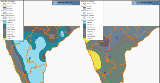
2002 (left) vs 2005 (right) annual rainfall in south India (caption from the webmapping IFP)
Semi-arid climate
The semi-arid area of the Deccan plateau is marked by a high variability of annual precipitation. For instance, the major part of the Deccan plateau has suffered a severe climatic drought during the year 2002 (annual precipitation < 600mm/y) whereas the region has experienced an exceptional monsoon during the year 2005 (between 2000 and 3000 mm/y).
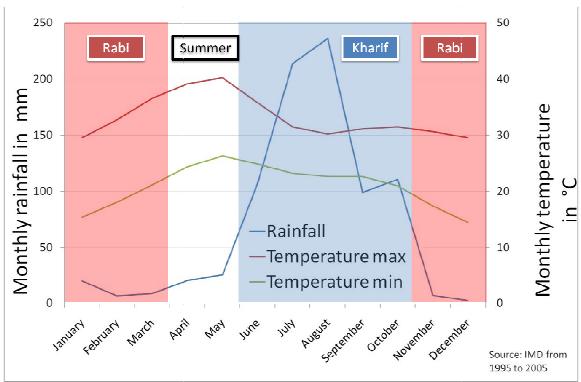
The climate is marked by two seasons, the dry season (Rabi) and the monsoon season (Kharif, 80% of the annual rainfall) which is subject to be more or less humid.
In this semi-arid, rural and highly populated area, irrigated agriculture has been developed to sustain the agricultural rice and vegetable production, during both seasons.
The irrigated water is mainly extracted from the groundwater by local pumping. During climatic drought, this resource acts as a buffer water supply.
Spatial irrigation demand estimate
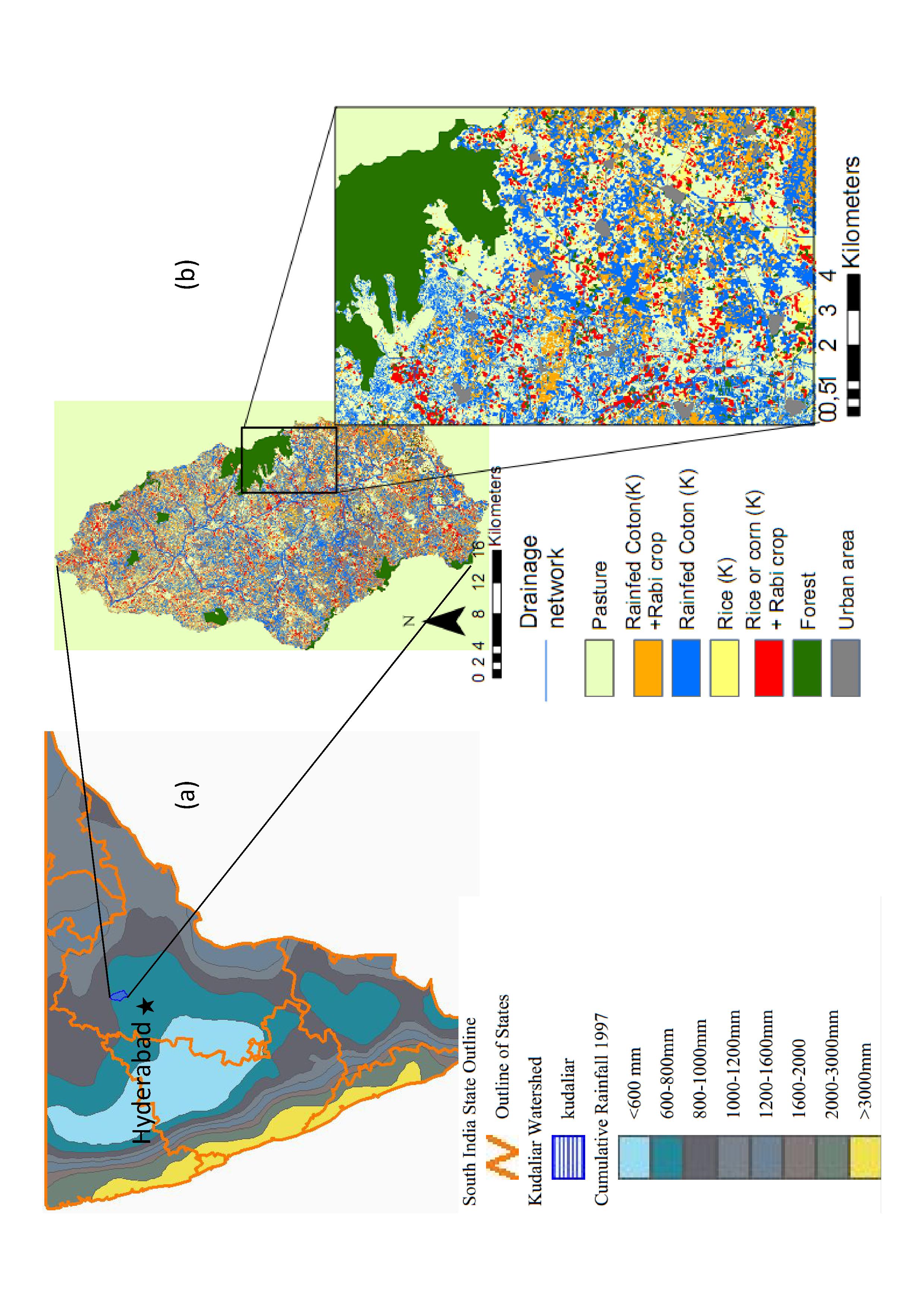
Agricultural land use of the Kudaliar river basin.
Based on a field work (land use survey) and a satellite imaging classification during the two seasons (kharif 2009 and Rabi 2010), irrigated crops have been identified on the study site.
The high density of small irrigated areas plot implies a high density of boreholes. They are used to pump into the groundwater to fulfill the local irrigation needs.
The hydrological fluxes are dominated by vertical flows (recharge, pumping and evapotranspiration) rather than horizontal flows (run-off, lateral flow and discharge).
We have associated seasonal irrigation practices to each crop to compute an annual theoretical water extraction map.
Irrigated area per season
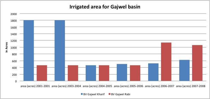
irrigated area extent in acre in Gajwel area, Governmental statistic.
Governmental statistics indicate that irrigated area extent varies from year to year, depending on previous climatic drought and water availability in the aquifer.
In the Gajwel catchment, this farmer adaptation to the water availability explains a variation of the annual water extracted from 50 mm/y (minimum of irrigated area extent) to 230mm/y (maximum of the irrigated area extent).
An increase of irrigated area extent has been observed since 30 years, increasing by 28% during the 80s and again by 105% during the 90s to reach the nowadays observed range of groundwater extracted for irrigation.
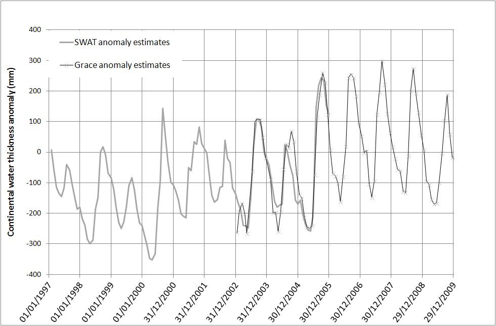
Groundwater storage variation
Both climate variability and irrigation demand highly modify the groundwater storage within the aquifer.
This figure shows the continental water (surface water, soil water and groundwater) simulated for a period of 12 years using Indian Meteorological Department data until 2005 (Rajeevan et al., 2008) in the agro-hydrological model SWAT calibrated in Gajwel area. The model validation is performed on the monthly continental water storage estimated from GRACE satellite data downloaded here.
The simulation illustrates the climate variability impact on the groundwater storage, rather than the groundwater extraction, which has been fixed into the model to the actual observed values (2009-2010 field campaign).
Oral presentation of major results at the project final meeting.
Organized by the team project in Hyderabad, India (02nd of July 2013).
Poster presentation in Environmental changes seminary,Organized by ANR in Toulouse (17-18th April 2013)
|
| ||
Poster presentation in American Geoscience Union international conference
AGU in San Francisco (Dec., 2010)
|
| ||
References for this work:
A methodological report is published on the SHIVA project website, and is available here. A preliminary calibration of the agro-hydrological model on a set of data for the Gajwel catchment has been published in journal of hydrology (Perrin et al., 2012) to report the interest of the methodology. An other publication is submitted to nature scientific report and present the likely effect of the regional climate changes on the groundwater storage and uses.
